H2iber PROJECT PLATFORM
The main objective of the project H2iber: Assessment and Management of water resources in renewable H2 projects, is to improve the management of water resources in renewable hydrogen projects.
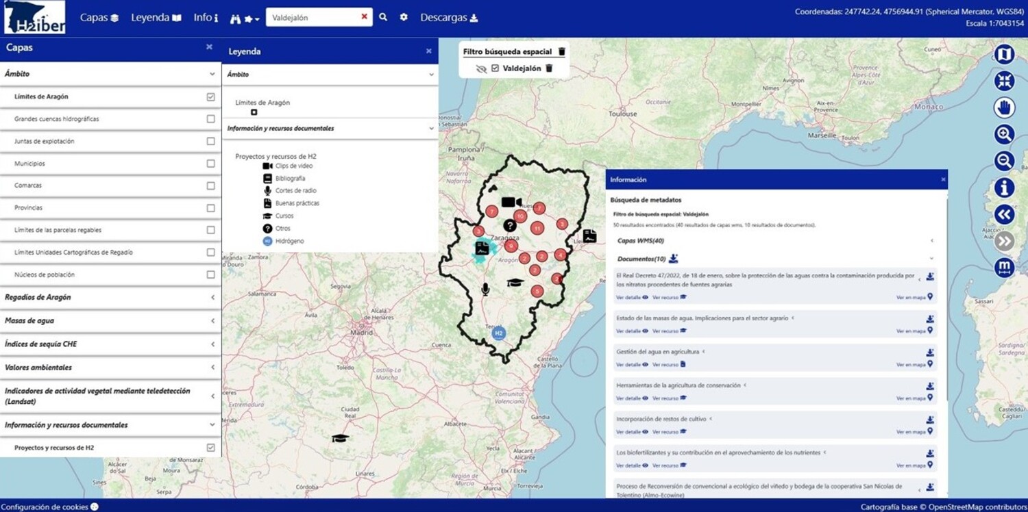
From Geoslab we have been working on collecting information and making it available in an intuitive and accessible way through a web tool. The prototype is available at: https://h2iber.geoslab.com/h2iber/
This tool has a catalogue of geolocated, meta-dated and categorised resources. According to their nature, they can be of different types and are represented with an identifying icon on the map (scientific articles, news in the media, videos, courses, projects and others).
When entering the map, a small sample of the resources that we have considered most relevant is automatically offered, but the catalogue has hundreds of resources that can be freely explored through the search engine.
On top of this catalogue, an application has been built that allows to explore and analyse in an intuitive way all the available information and provides an environment to facilitate decision making.
This application includes a map viewer in which the different georeferenced resources can be combined. Some of them are public data provided by official sources such as the Spatial Data Infrastructure of Spain (IDEE), AEMET, the Ministry of Agriculture or the Ebro River Basin (CHE). All of them have been organised in a content tree in which have been included layers with relevant information for the context of the project and that have to do with the river network and the available bodies of water; the different consumptions that are carried out on them and the environmental scope.
In particular, we provide layers organised according to the following content tree:
- Geographical layers: municipalities, counties, provinces, large hydrographic basins, etc.
- Irrigation in Aragon: irrigable plots, irrigation communities and irrigation mapping units (UCR).
- Crops-% surface area per UCR: intensive crops (fruit and horticultural crops) and extensive crops (maize, other cereals and fodder crops).
- Water bodies: River network, reservoirs, basins and groundwater bodies.
- Drought indices of the Ebro Hydrographic Confederation (CHE).
- Environmental values: landscape, Natura 2000 network, species protection areas and critical species areas.
- Indicators of plant activity by remote sensing (Landsat).
- H2 projects and resources
As these are heterogeneous resources, it is particularly interesting to search from different perspectives in order to be able to complement information from different sources and make more efficient water management decisions.
As mentioned above, the application developed allows us to freely explore all the resources available in the catalogue through the search engine, developing searches according to different criteria:
- Free search: by free text
- Search by theme: according to the following defined themes: H2, Energy, Water, Irrigation, Environment and Meteorology.
- Geographical search: by region or municipality
To build the tool we have implemented an infrastructure based on open source software, OSGeo (OpenSource Geospatial Foundation) projects and OGC (Open Geospatial Consortium) standards.
Specifically, the components used are:
- PostgreSQL + PostGIS as spatial database
- GeoNetwork as metadata catalogue
- Geoserver as spatial data publishing service
- OpenLayers as map viewer and OSM and PNOA as base cartography.
The incorporation of Artificial Intelligence (AI) in the tool will focus on making it easier for users to carry out searches, proposing the most commonly used terms, types of resources, etc.
In the future, when a sufficient amount of data is available, it will be possible to use this technology to perform calculations that will allow forecasts of water availability at a given time and place.
Project reference AEI-010500-2023-286. Grants to support Innovative Business Groupings with the aim of improving the competitiveness of small and medium-sized enterprises, call for proposals 2023, within the framework of the Recovery, Transformation and Resilience Plan.


